Investigation of a glacier moraine in Antarctica
Issue
In order to assess the feasibility of the construction of an airstrip in Antarctica, the stability conditions of a moraine deposit chosen as potential location for the project need to be assessed.
Solution
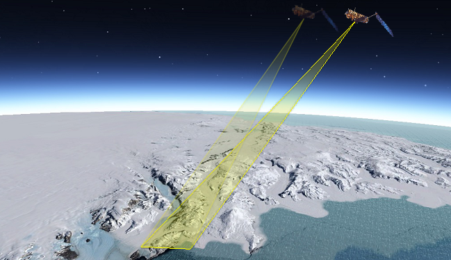
The most appropriate solution has been a remote sensing technique as the satellite lnSAR, carried out by analysing historical archive images acquired by COSMO-SkyMed constellation in the previous 2 years. In such a way, several issues affecting the case like the extreme climate environment and the need to achieve quantitative information about displacements occurred due to the peculiar active processes in the area (i.e. glaciers) have been addressed.
Achievement
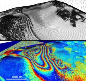
Results coming from both DlnSAR and A-DlnSAR analyses allowed to define the deformation pattern of the areas including the active glacier flowing aside the morein, thus defining the behavior of this geomorphological structure. Thanks to the capability of satellite SAR systems, able to acquire information both during night and day and to penetrate the cloud coverage, information for the whole 2-years period was acquired despite the long polar-night period and the presence of not good visibility.
For further details:
Urbini S., Bianchi-Fasani G., Mazzanti P., Rocca A., Vittuari L., Zanutta A., Girelli V.A., Serafini M., Zirizzotti A., Frezzotti M., 2019, Multi-Temporal Investigation of the Boulder Clay Glacier and Northern Foothills (Victoria Land, Antarctica) by Integrated Surveying Techniques, Remote Sensing – MDPI.